Taking your own car to Northern Norway gives you wonderful freedom. Here are some tips and advice on driving to Northern Norway.
Every summer, tens of thousands of motorists drive up into Northern Norway from the south of Norway, Scandinavia, and Europe. Some even dare to come in winter and encounter surprisingly few problems. Although Northern Norway is quite remote, it is remarkably easy to get there in your own car. Many people choose to take the fast roads through Sweden or Finland, while others choose the more winding but much more scenic roads of Norway.
The Northward journey through Norway
The E6, Norway’s main north-south artery, is of a good standard throughout, and can generally be driven without any problems all year round. From Majavatn at the Trøndelag county boundary, it runs 1,670 kilometres (1,038 miles) to Kirkenes, via Fauske (close to Bodø), Narvik, Bardufoss, Alta, Lakselv and Tana Bridge. There is still one ferry on the route, from Bognes to Skarberget between Bodø/Fauske and Narvik. A more scenic alternative is Fv17, the Coastal Route. This National Tourist Route is an attraction in itself, but it takes much longer to drive, because of its many ferries.
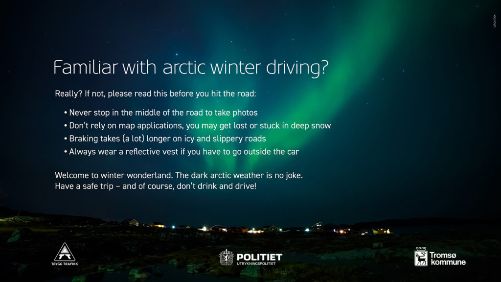
Winter weather can close roads
Occasionally, the mountain passes on the E6 are closed because of bad weather in winter. The passes generally open again after a few hours. You can obtain updated information on the Norwegian Public Roads Administration’s website and on the radio while petrol stations and roadside restaurants also tend to have the latest updates. The most frequent winter closures on the E6 are in the following places:
- Saltfjellet (between Mo i Rana and Rognan)
- Kvænangsfjellet (between Storslett and Burfjord)
- Sennalandet and Hatter (between Alta and Lakselv/North Cape)


Driving a foreign registered vehicle in Norway?
All foreign and domestic vehicles must pay road tolls in Norway. You have three payment options for all vehicles up to 3,500 kg. Read more at AutoPass.no.
Frequently asked questions
Saltfjellet (between Mo i Rana and Rognan). Kvænangsfjellet (between Storslett and Burfjord), and Sennalandet and Hatter (between Alta and Lakselv/North Cape) are all roads that from time to time get closed due to bad winter weather.
Many people from southern Scandinavia and the continent choose to get to Northern Norway by driving through Sweden or Finland. The roads there are more direct, with higher speed limits, meaning that you can eat up the miles very quickly. You then have to cross over into Norway on one of the many international roads:
These roads are rarely closed in the winter. From west to east:
E8 Rovaniemi – Kaaresuvanto (bridge to Karesuando, Sweden) – Kilpisjärvi – Skibotn – Tromsø
E93 Rovaniemi – Hetta – Kautokeino – Alta – North Cape
E92 Rovaniemi – Ivalo – Karigasniemi – Karasjok – North Cape
E75 Rovaniemi – Ivalo – Utsjoki – Tana
Rv893 Rovaniemi – Ivalo – Näätämö – Neiden – Kirkenes
Yes, but a Visa is needed to cross the border. Go by the road E105 Murmansk – Zapoljarnij in Russia, to Storskog – Kirkenes in Norway.
Oslo – Brønnøysund: 864 km (537 miles), 12 hours, E6 and Fv17
Oslo – Bodø: 1,197 km (744 miles), 16 hours, E6 to Fauske, Rv. 80
Oslo – Lofoten Islands : 1,450 km (900 miles), 20 hours via E6, ferry from Bognes to Lødingen
Oslo – Tromsø: 1,642 km (1,021 miles), 22 hours, E6, E8 from Nordkjosbotn
Oslo – North Cape: 1,985 km (1,233 miles), 25 hours (via Sundsvall/Sweden, Kautokeino)
Oslo – Kirkenes: 1,915 km (1,190 miles), 24 hours (via Sundsvall, Rovaniemi (Finland))
Amsterdam – Svolvær: 2,842 km (1,766 miles), 33 hours via Stockholm, Arjeplog, Junkerdal, Fauske.
Staten vegvesen – the Norwegian Public Road Authorities – has made an easy-to-read article on driving safely in Norway.